Scientific research indicates that the Global Mean Sea Level has been increasing since the 1990’s, which has seen an SLR rate of around 3 millimeters (0.14 inches) per year, roughly twice the rate seen during the past 100 years. Rise in sea levels is linked to several primary climate-related factors, all induced by this ongoing global change:
- Water thermal expansion: Simply put, as water heats up, it expands to fill more space. Almost half of the past century’s rise in sea level has been attributed to warmer oceans, which occupy more space than they did previously.
- Melting of glaciers and polar ice caps: Large ice formations, including glaciers and polar ice caps, naturally melt back as temperatures rise each summer. Normally in the winter colder temperatures produce snow and ice, made primarily from evaporated seawater, in amounts that are normally sufficient to balance out summer melting. Recently, however, persistent higher temperatures attributed to global warming have led to above-average summer melting, diminished winter snow/ice production and earlier spring thaws which cause a significant net gain in runoff versus evaporation for the ocean leading to increasing sea levels.
Another factor, which is not directly climate related, that can increase the rate of habitat loss and intensify the impacts of SLR is the subsidence of coastal lands. Land subsidence, which is the sinking of a land mass, is also occurring in many areas around the world. When subsidence rates are combined with SLR the actual loss of wetland habitats becomes accelerated. In the US, subsidence is occurring in many areas but is of particular concern in the Gulf States, especially in the Mississippi delta region.
As sea levels continue to rise thousands of cities and villages around the world will be impacted creating a likelihood that entire island chains and low lying coastal plains may become submerged by the end of the century and their populations displaced. As the global community braces for an uncertain future, apprehensions about future impacts to coastal populations are leading to new scientific methods and integrated approaches in an effort to develop new tools for governments, natural resource managers and community planners to better inform their decision making processes with regard to rising sea levels. One of these tools, which is currently being use in natural resource management, is the Sea Level Affecting Marsh Migration model (SLAMM), which uses advanced GIS technology to predict how marshes will be affected over time as sea levels continue to rise.
SLAMM:
Sea Level Affecting Marshes Model (SLAMM) is a spatial computer model that uses historical and current wetland data with elevation datasets to predict tidal marsh migration and/or transformation under future sea level rise (SLR) conditions. The SLAMM model accounts for the dominant processes involved in wetland conversion and shoreline modifications during long-term SLR and is used to predict changes in tidal marsh area and habitat type in response to various SLR future scenarios.
SLAMM 6.0
SLAMM was developed with EPA funding in the mid-1980s and since its initial release has been through multiple upgrades, including SLAMM 6 (2010 release), as a result of feedbacks from other scientists working in the field. For a thorough accounting of SLAMM model processes and the underlying assumptions and equations, please see the SLAMM 6.0 Technical Documentation which can be found at http://warrenpinnacle.com/prof/SLAMM.
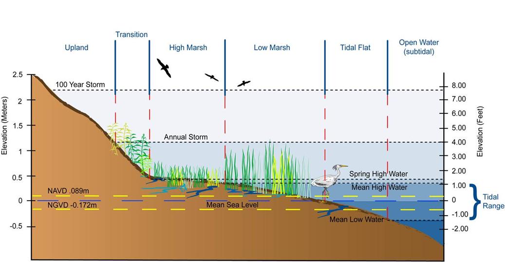
Wetland Classifications (Source: Warren Pinnacle Consulting Inc.)
A complex decision tree incorporating geometric and qualitative relationships is used to represent transfers among coastal habitat classes as SLR. Within SLAMM, there are five primary processes that affect wetland fate under different scenarios of SLR:
- Inundation: The rise of water levels and the salt boundary are tracked by reducing elevations of each cell as sea levels rise, thus keeping mean tide level constant at zero. The effects on each cell are calculated based on the minimum elevation and slope of that cell.
- Erosion: Erosion is triggered based on a threshold of maximum fetch and the proximity of the marsh to estuarine water or open ocean. When these conditions are met, horizontal erosion occurs at a rate based on site-specific data.
- Overwash: Barrier islands of under 500 meters width are assumed to undergo overwash during each specified interval for large storms. Ocean beach migration and transport of sediments are calculated.
- Saturation: Coastal swamps and fresh marshes can migrate onto adjacent uplands as a response of the fresh water table to rising sea level close to the coast.
- Accretion: SLR is offset by sedimentation and vertical accretion using average or site-specific values for each wetland category. Accretion rates may be spatially variable within a given model domain and can be specified to respond to feedbacks such as frequency of flooding.
SLAMM predictions are generally obtained by two consecutive steps. The first step involves calibrating the model using available historical wetland and SLR data, which is referred to as the “hindcast”. After calibration the model is then run to develop various possible scenarios of wetland changes in response to a range of estimated future SLR and different management regimes for the purpose of understanding how these various factors might affect future wetland habitats. SLAMM was implemented in this project by Warren Pinnacle Consulting, Inc., a consulting firm that specializes in running SLAMM.
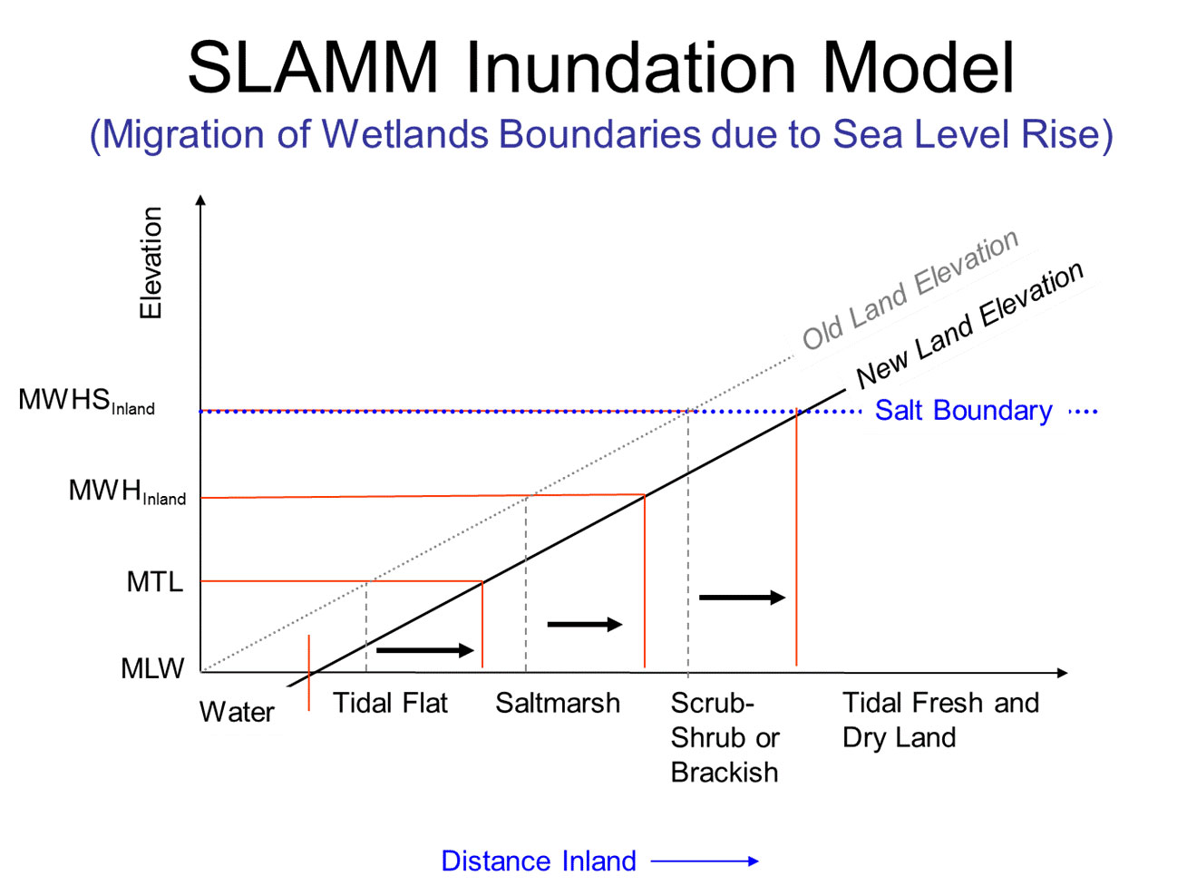
SLAMM Inundation Model (Source: Warren Pinnacle Consulting Inc.)
SLAMM Scenarios
SLAMM results for these analyses were run using scenario A1B from the 2000 Intergovernmental Panel on Climate Change’s Special Report on Emissions Scenarios (SRES) – mean and maximum estimates. The A1 family of scenarios assumes that the future world includes rapid economic growth, global population that peaks in mid-century and declines thereafter, and the rapid introduction of new and more efficient technologies. In particular, the A1B scenario assumes that energy sources will be balanced across all sources. Under the A1B scenario, the 2007 IPCC WGI Fourth Assessment Report suggests a likely range of 0.21 to 0.48 meters of SLR by 2090-2099 “excluding future rapid dynamical changes in ice flow”. The A1B-mean scenario that was run as a part of this project falls near the middle of this estimated range, predicting 0.39 m of global SLR by 2100. A1B-maximum predicts 0.69 m of global SLR by 2100. To allow for flexibility when interpreting the results of these analyses, SLAMM was also run assuming 1, 1.5, and 2 meter(s) of eustatic SLR by the year 2100. The A1B- maximum scenario was scaled up to produce these bounding scenarios.

2100 Sea Level Rise Scenarios used for SLAMM model
On the temporal scales used in this project, each SLAMM simulation is run starting from the National Wetland Inventory (NWI) photo date as the initial condition. In these studies the time-step was selected to be 25 years for forecasting and 5 years for hindcasting. This choice resulted in model output for years 2025, 2050, 2075, and 2100 for forecasting simulations.