Storm surges generated by tropical storms and hurricanes are a constant threat to coastal communities, particularly to those communities located in low-lying areas along the coastal plains in the US East coast and the Gulf of Mexico. In order to better understand the potential threats of storm surge, modeling efforts using past hurricane events can help communities and governments better prepare for the effects of future storm surge events. Rising sea levels in the future can further exasperate storm surge damages by increasing the elevation of water levels, and the height of storm surges, in these coastal communities.
Storm surge modeling was motivated by the need to provide a series of technical tools to the members of the Governor’s Gulf of Mexico Alliance to better understand the effects of sea level rise (SLR) coupled with storm surge in key coastal areas. The implementation of the ADvanced CIRCulation (ADCIRC) model analysis, which incorporates future SLR scenarios, complements the information produced by previous studies conducted by The Nature Conservancy (TNC). The ADCIRC model spatial outputs provided as part of this effort will help coastal managers, scientist and the conservation community in identifying the additional threat posed by storm surge and one meter of SLR by 2100.
ADvanced CIRCulation (ADCIRC) Model:
ADCIRC was selected for our storm surge analyses, as it is a highly vetted complex hydrodynamic spatial model commonly utilized as the standard coastal storm surge model used by the U.S. Army Corps of Engineers (USACE), and the U.S. Federal Emergency Management Agency (FEMA). As a physics-based model and it is commonly applied for tidal studies, hurricane storm surge and flooding applications used by state and federal agencies throughout the United States. It consists of a system of computer programs for solving time dependent, free surface circulation and transport problems in two and three dimensions (http://adcirc.org). These programs utilize the finite element method in space allowing the use of highly flexible, unstructured grids that run in a supercomputer cluster system.
The critical inputs for this study are the unstructured computational mesh, surface characteristics (e.g. land cover rugosity), and meteorological forcing, such as wind and pressure fields. The primary data sources for this study are topographic, bathymetric and land cover data that are applied to the ADCIRC mesh and surface characteristics files. ADCIRC meshes were assembled by applying the most recent topographic and bathymetric surveys available similar to those used by FEMA, including lidar-based elevations and natural and dredged channel and dike surveys.

ADCIRC Mesh with 2004 Topographic Contours (feet NAVD88) for the Galveston Bay and Jefferson County Study Areas (source: ARCADIS, Inc.)
The storm surge models used land cover information derived from the Coastal Change Analysis Program (C-CAP and the National Land Cover Dataset). For this study, SLAMM 1 meter SLR scenario output data for 2050 and 2100 was applied where available and supplemented by C-CAP data outside of the SLAMM domain. ADCIRC was coupled with the unstructured Simulating WAves Near-shore (UnSWAN) wave model. The UnSWAN model was selected for two reasons. First, STWAVE wave radiation stresses produced for the hurricane hindcast. The FEMA mesh was edited for this study to speed up computational time. Secondly, UnSWAN and STWAVE wave radiation stresses have were found to have similar effects on storm surge when hincasting several hurricanes. UnSWAN and ADCIRC are coupled on a ten minute interval for this analysis. Storm surge analysis was implemented in this project by Arcadis US Inc., a consulting firm that specializes in running ADCIRC. The results of the storm surge scenarios were used to derive the statistical analysis of inundation for our study sites.
Scenarios:
Three scenarios of storm surge were created using the ADCIRC hydrodynamic model that assimilated the resulting SLAMM scenarios of SLR. These included initial conditions and two future scenarios, for the years 2050 and 2100, which incorporated 1 meter of sea level rise by 2100. Hurricanes storm surges were modeled after actual previous events and were selected based on their temporal and spatial proximity to our study areas (one for each project site – e.g. H. Ike in September 2008 for the Galveston Bay and southern Jefferson County project sites).
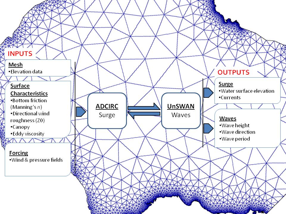
ADCIRC Model Schematic (source: www.adcirc.org)